Publications tagged "sustainability"
-
 PreprintarXiv preprint arXiv:2602.21421 2026
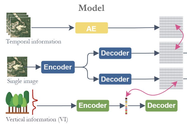
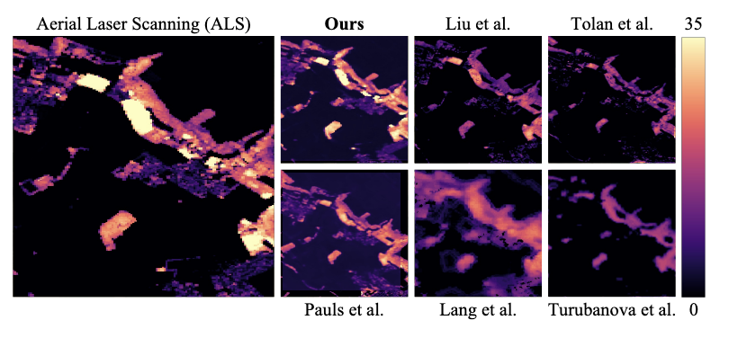
Forest monitoring is critical for climate change mitigation. However, existing global tree height maps provide only static snapshots and do not capture temporal forest dynamics, which are essential for accurate carbon accounting. We introduce ECHOSAT, a global and temporally consistent tree height map at 10 m resolution spanning multiple years. To this end, we resort to multi-sensor satellite data to train a specialized vision transformer model, which performs pixel-level temporal regression. A self-supervised growth loss regularizes the predictions to follow growth curves that are in line with natural tree development, including gradual height increases over time, but also abrupt declines due to forest loss events such as fires. Our experimental evaluation shows that our model improves state-of-the-art accuracies in the context of single-year predictions. We also provide the first global-scale height map that accurately quantifies tree growth and disturbances over time. We expect ECHOSAT to advance global efforts in carbon monitoring and disturbance assessment.
@article{pauls2026echosat, title = {ECHOSAT: Estimating Canopy Height Over Space And Time}, author = {Pauls, Jan and Schr{\"o}dter, Karsten and Ligensa, Sven and Schwartz, Martin and Turan, Berkant and Zimmer, Max and Saatchi, Sassan and Pokutta, Sebastian and Ciais, Philippe and Gieseke, Fabian}, journal = {arXiv preprint arXiv:2602.21421}, year = {2026}, } -
 ICML25 Forty-second International Conference on Machine Learning 2025
Significant efforts have been directed towards adapting self-supervised multimodal learning for Earth observation applications. However, existing methods produce coarse patch-sized embeddings, limiting their effectiveness and integration with other modalities like LiDAR. To close this gap, we present DUNIA, an approach to learn pixel-sized embeddings through cross-modal alignment between images and full-waveform LiDAR data. As the model is trained in a contrastive manner, the embeddings can be directly leveraged in the context of a variety of environmental monitoring tasks in a zero-shot setting. In our experiments, we demonstrate the effectiveness of the embeddings for seven such tasks (canopy height mapping, fractional canopy cover, land cover mapping, tree species identification, plant area index, crop type classification, and per-pixel waveform-based vertical structure mapping). The results show that the embeddings, along with zero-shot classifiers, often outperform specialized supervised models, even in low data regimes. In the fine-tuning setting, we show strong low-shot capabilities with performances near or better than state-of-the-art on five out of six tasks.
@inproceedings{fayad2025dunia, title = {DUNIA: Pixel-Sized Embeddings via Cross-Modal Alignment for Earth Observation Applications}, author = {Fayad, Ibrahim and Zimmer, Max and Schwartz, Martin and Ciais, Philippe and Gieseke, Fabian and Belouze, Gabriel and Brood, Sarah and De Truchis, Aurelien and d'Aspremont, Alexandre}, booktitle = {Forty-second International Conference on Machine Learning}, year = {2025}, url = {https://openreview.net/forum?id=JXCiQteuOv}, } -
 * equal contributionICML25 Forty-second International Conference on Machine Learning 2025
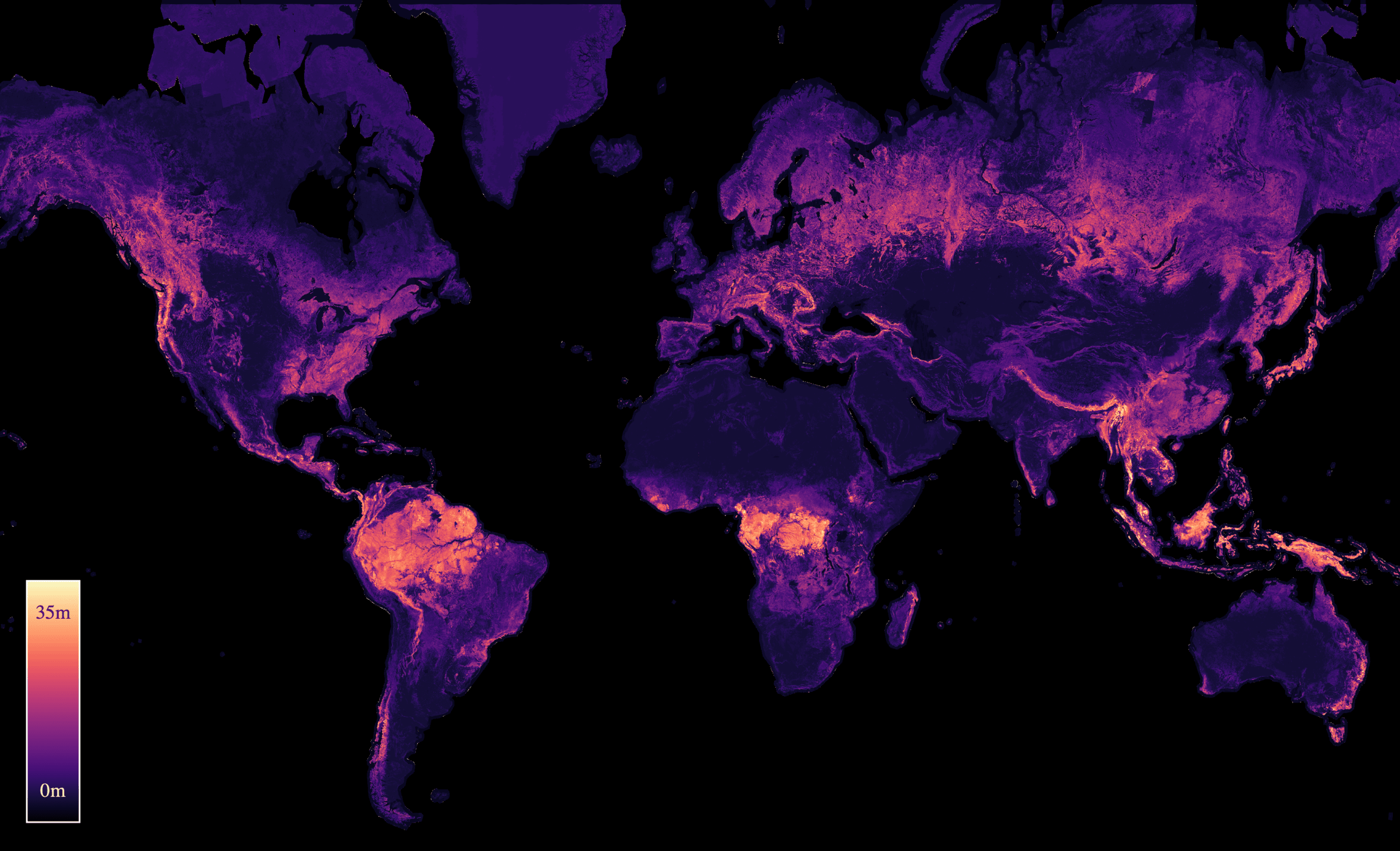
With the rise in global greenhouse gas emissions, accurate large-scale tree canopy height maps are essential for understanding forest structure, estimating above-ground biomass, and monitoring ecological disruptions. To this end, we present a novel approach to generate large-scale, high-resolution canopy height maps over time. Our model accurately predicts canopy height over multiple years given Sentinel-2 time series satellite data. Using GEDI LiDAR data as the ground truth for training the model, we present the first 10m resolution temporal canopy height map of the European continent for the period 2019-2022. As part of this product, we also offer a detailed canopy height map for 2020, providing more precise estimates than previous studies. Our pipeline and the resulting temporal height map are publicly available, enabling comprehensive large-scale monitoring of forests and, hence, facilitating future research and ecological analyses. For an interactive viewer, see this https URL.
@inproceedings{pauls2025capturing, title = {Capturing Temporal Dynamics in Large-Scale Canopy Tree Height Estimation}, author = {Pauls, Jan and Zimmer, Max and Turan, Berkant and Saatchi, Sassan and Ciais, Philippe and Pokutta, Sebastian and Gieseke, Fabian}, booktitle = {Forty-second International Conference on Machine Learning}, year = {2025}, url = {https://openreview.net/forum?id=ri1cs3vtXX}, } -
 ICML24 Forty-first International Conference on Machine Learning 2024
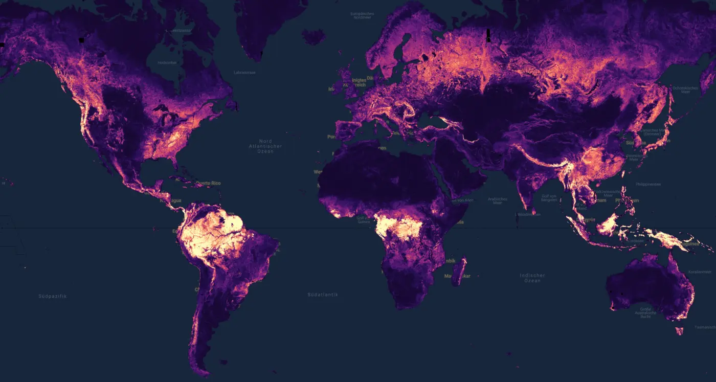
We propose a framework for global-scale canopy height estimation based on satellite data. Our model leverages advanced data preprocessing techniques, resorts to a novel loss function designed to counter geolocation inaccuracies inherent in the ground-truth height measurements, and employs data from the Shuttle Radar Topography Mission to effectively filter out erroneous labels in mountainous regions, enhancing the reliability of our predictions in those areas. A comparison between predictions and ground-truth labels yields an MAE / RMSE of 2.43 / 4.73 (meters) overall and 4.45 / 6.72 (meters) for trees taller than five meters, which depicts a substantial improvement compared to existing global-scale maps. The resulting height map as well as the underlying framework will facilitate and enhance ecological analyses at a global scale, including, but not limited to, large-scale forest and biomass monitoring.
@inproceedings{pauls2024estimating,
  title = {Estimating Canopy Height at Scale},
  author = {Pauls, Jan and Zimmer, Max and Kelly, Una M. and Schwartz, Martin and Saatchi, Sassan and Ciais, Philippe and Pokutta, Sebastian and Brandt, Martin and Gieseke, Fabian},
  booktitle = {Forty-first International Conference on Machine Learning},
  year = {2024},
  url = {https://openreview.net/forum?id=ZzCY0fRver},
}